Meet Forestum.ai: every tree in your forest, measured from a drone
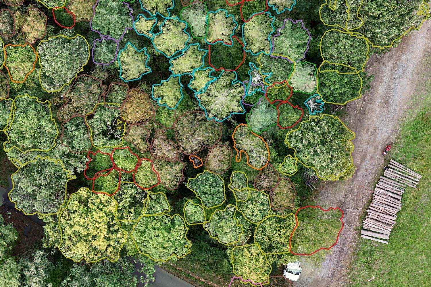
For years, Kindwise models have been answering one question for millions of users: what is this plant? With Forestum.ai we are scaling that question up from a single leaf to tens of thousands of hectares: what exactly is growing in this forest, where, and how much timber does it hold?
Forestum.ai is an AI platform for digital forest inventory. We fly a standard drone over the forest, optionally walk selected plots with a ground LiDAR scanner, and our machine-learning pipeline returns a georeferenced record for every individual tree: position (GPS coordinates), tree species, tree height, diameter at breast height (DBH) and timber volume.
No statistical sampling of 1–3 % of the area and extrapolation. We measure the whole stand, tree by tree, and deliver the result in formats foresters and GIS specialists already use.
It works: 70 hectares, 26,044 trees
Forestum.ai is not a lab demo. Together with our research partner, the Research Institute for Landscape (VÚK), we mapped 70 ha of mixed broadleaf forest at Ždánický les in South Moravia:
- 26,044 trees individually detected and mapped,
- 16,281 m³ of estimated growing stock,
- 5 genera classified: oak, hornbeam, larch, pine and ash,
- full GIS layer, orthophoto, canopy height model and per-species statistics for the whole area.
The results were presented at the Czech forestry conference Lesník 21. století and featured in a report by Czech Radio. Today we have five commercial projects underway, two of them already delivered.
What you get: two ways to measure a tree
1. Drone imagery (the baseline). RGB photos at 1–5 cm per pixel cover the entire area. That is roughly 10,000 pixels per square metre, compared with 64 from standard national aerial imagery. From the photos we build an orthophoto and a canopy height model; our models then find each crown, identify the genus and estimate height, DBH and volume. We can cover hundreds of hectares in a single day.
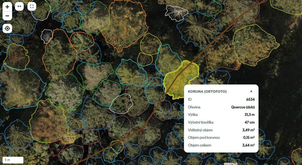
A tree detected from drone imagery only. Oak (Quercus), 31.3 m tall, DBH 47 cm. Visible volume 3.49 m³ plus 0.15 m³ estimated under the crown, 3.64 m³ in total.
2. Ground LiDAR (optional). On selected plots we add a short walk with a ground laser scanner. LiDAR sees trunks under the canopy, measures the stem directly at 1.3 m, and we use it to calibrate the drone model for the whole area, including the understorey that is invisible from above.
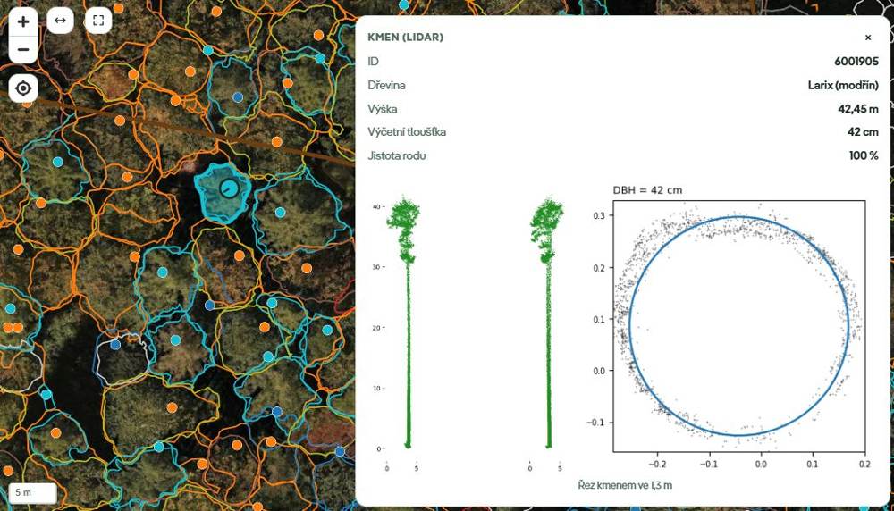
Where LiDAR is available: European larch (Larix), 42.45 m, DBH 42 cm fitted directly to the point-cloud cross-section at 1.3 m, genus confidence 100 %.
Everything is delivered ready to use:
- GIS data (GeoJSON / GeoPackage / Shapefile, CSV) – one point per tree with all attributes,
- map rasters (GeoTIFF) – full-resolution orthophoto and canopy height model (CHM),
- PDF report and XLSX tables – statistics per species and per stand, ready for forest management plan workflows,
- interactive web map where you click a crown and see the tree.
The numbers we are proud of
We test the hard way: on forests the model has never seen during training, against a full ground survey of every stem, not against crowns somebody traced on a screen.
Timber volume within the legal limit. Czech regulation (Decree 84/1996) allows a maximum 10 % error of growing stock for forest management plans. Forestum.ai drone-only analysis reached 8 % stand volume error in the worst of ~5 forests measured in autumn 2026. Combining drone and LiDAR, the volume on our three test plots matched the field survey within 5 %.
Tree-level accuracy on independent test plots (November 2026):
- Trees found: 78–88 % of trees visible from above with the drone; 74–98 % of all trees, including understorey, with ground LiDAR.
- Genus correctly identified: 79–87 % from the drone.
- Tree height: mean absolute error 0.5–2.8 m from the drone.
- DBH: mean absolute error 4.1–5.1 cm from the drone, 1.5–2.4 cm with LiDAR.
The economic core of the forest. From above, the drone sees the dominant canopy. On our plots that is 57–81 % of the trees, but they hold 76–94 % of the timber volume. The trees we miss are mostly thin, suppressed understorey. LiDAR closes that gap where it matters.
Where we beat the state of the art
Published papers often report near-perfect scores, but mostly on plantations, parks, or with the model tested on the same site it was trained on. Moved to a new mixed forest and checked against real stems, accuracy in the literature typically drops to F1 0.22–0.64. Here is how Forestum.ai compares in this realistic setting:
- Crown detection and segmentation: Forestum.ai reaches F1 0.69–0.77 with precision 80–95 % on an unseen mixed oak–hornbeam forest. Published transfer results for open-source baselines in a new deciduous forest: Detectree2 F1 0.57, DeepForest F1 0.22 (Gan et al. 2023); a mixed-forest CNN F1 0.64 and a universal model F1 0.40 (Ritz et al. 2025).
- DBH estimated from the crown: using genus-specific allometry, our error for oak is MAE 2.94 cm (RMSE 3.8 cm) and for hornbeam MAE 2.64 cm. A comparable UAV study of oak in mixed forest reports RMSE 11.12 cm (Karthigesu et al. 2025), roughly three times worse.
- Growing stock: drone-based photogrammetric inventories in the literature typically show 14.5–46.7 % volume error (Puliti et al.). Forestum.ai stays under 10 %.
- Species makes LiDAR better: adding genus from the drone to LiDAR raised captured volume from 80.5 % to 91.7 %, because each species has its own volume equation.
Accurate data at close to the price of a guess
Forest owners today choose between two extremes: a cheap ocular estimate for the management plan (20–30 % error, no tree in the map) or manual calipering of every stem (±5 %, from about €80 per hectare, weeks in the field).
Forestum.ai sits in between, on the accurate side. On the 70 ha Ždánice forest a turnkey analysis including the drone flight costs about 93,000 CZK; full calipering starts at 140,000 CZK. If the customer flies their own drone, the price drops to around 37,000 CZK.

Forestum Lite stays under the 10 % statutory limit at a fraction of the cost of manual measurement.
Who is Forestum.ai for
- Forest owners and managers – state forests, municipalities and regions, church and private estates, cooperatives. Know what you own, plan harvests on real numbers and document the value of your stand.
- Forest management planners and inventory specialists – a precise digital tree map before going to the field. We don't replace the forest management plan; we deliver the data it can be built on.
- Drone and survey companies – you fly, we turn your imagery into a forest inventory product you can sell.
- Infrastructure operators – trees along power lines, railways and roads, with height and species.
- Anyone reporting on forests – documentation for EUDR, subsidies, certification, insurance after a calamity, and repeat monitoring of growth and change without another field campaign.
Built on Kindwise know-how
Forestum.ai builds on a decade of computer-vision experience behind plant.id, insect.id and mushroom.id, and on close collaboration with forestry scientists at VÚK. The project is co-financed by the European Union under the OP TAK programme. We currently operate across the Czech Republic, with other Central European countries coming soon.
See your own forest
Want to know what is really growing in your forest, tree by tree? Book a free 30-minute consultation – we reply within 24 hours.
👉 Visit forestum.ai and explore the interactive Ždánice case study.
References: Gan, Wang & Iio (2023), Remote Sensing 15(3):778 · Ritz et al. (2025), Int. J. Remote Sens. 47(1) · Karthigesu et al. (2025), Geomatics 5(1):12 · Puliti et al. (2015–2019) · Allen, Owen et al. (2025), arXiv:2503.14273.


Production release: insect.id & mushroom.id

Crop.health: curing crops, empowering farmers

Unearthing the Journey: Rock.id API

Batch species identification from photos: plants, insects, fungi

Meet the new Mushroom ID!

Do The Different Light Conditions Have An Influence On Plant.Id Identification Accuracy?

Insect.id API beta release is here!

Use Plant.Id Demo As An App
